Activity directions >>> Scientific activity
В данное время это направление деятельности не ведется
Space-photographing oil forecast at the Yugra territory
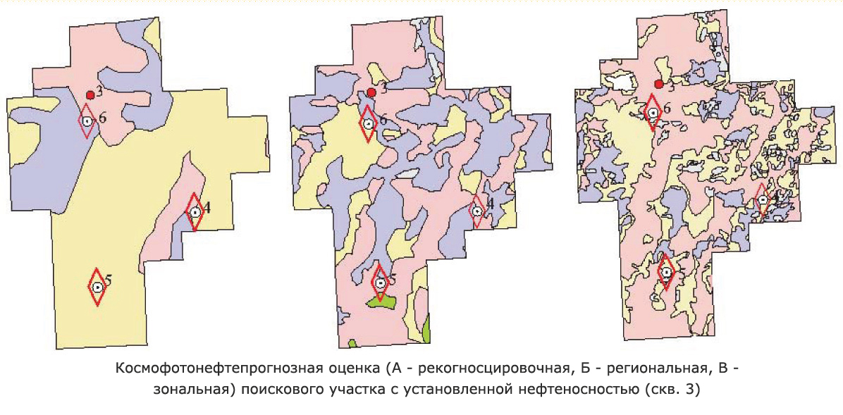
Space-photography decoding used for oil forecast is a part of the complex for petroleum geology studies of the territory. It is conducted at the reconnaissance regional, zonal stages of oil prospecting at the Yugra territory. High reliability of oil forecast by space-photography decoding is proved by time at each stage.
RECONNAISSANCE SURVEY (SCALE 1:1 000 000)
Reconnaissance survey is carried out on the results of decoding of black and white space images at a scale mainly close to scales 1:2 500 000, 1:1 000 000.
For the western and eastern parts of the Okrug there were constructed maps of oil presence forecast at a scale 1:1 000 000, the distantly investigated areas being classified as oil promising and oil unpromising.
Time confirmed the reliability of oil forecast.
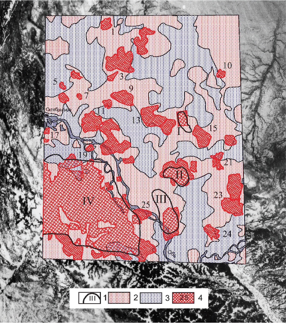
Example: In 1984 the western part of the Ob river basin was evaluated using space photography oil forecast, where four oilfields had been discovered: Aprelskoye (No.1 in the Figure), Srednenazymskoye (II), Galyanovskoye (III) and Krasnoleninskoye (IV); these data served as «supportive» information for decoding oil promising areas (Mark 2 in the Figure).
In 20 years time it appeared that at the mapped territory 25 more oilfields (mark 4) were discovered, and among them Yuzhno- Amninskoye (No.1 in the Figure), Oktyabrskoye (No.5), Tsentralnoye (No.9), Nazymskoye (No.13), Maloatlymskoye (No.19), Vostochno-Kamennoye (No.25).
Only one discovery (No.5 in the Figure) was found at the territory identified as unpromising (Mark 3). One oilfield, Yemangalskoye (No.21) was evaluated by using this forecast ambiguously.
In total, 95 oilfields were discovered (after space images decoding) in the areas evaluated with space images data at the reconnaissance stage. As much as 75% of these discoveries (71 oilfields) appeared to be located at the territories identified by space images decoding data as oil promising, 15%, i.e. 14 oilfields, were opened at the territory specified by cosmographic data as unpromising; 10 discoveries in this forecast were identified as ambiguous.
Practically, the whole Yugra territory was covered by reconnaissance survey through space images decoding for evaluating oil presence.
REGIONAL SURVEY (SCALE 1:500 000)
Regional studies are carried out with the aid of white and black space images having scales of about 1:1 000 000 and 1:500 000. For separate areas of Yugra there were constructed maps at a scale of 1:500 000 of distant evaluation with differentiation of three groups of areas.
Space photographiy for evaluation of oil presence appeared to be rather reliable.
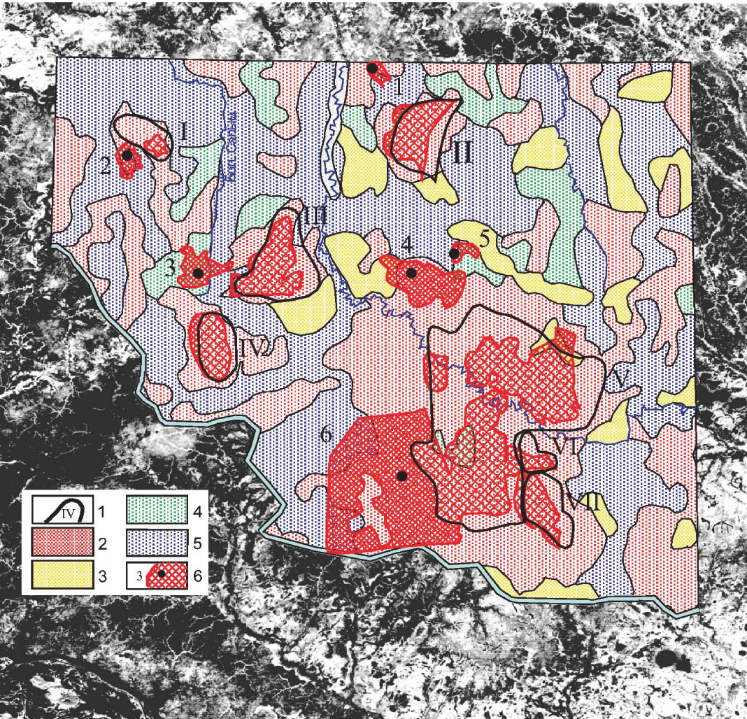
An example of space photography for oil presence forecasting which was confirmed by time (the Bolshoi Yugan river basin). Prior to conducting space images decoding there were opened the following oilfields: Tukanskoye, Aikurusskoye, Polun'yakhskoye (III in the Figure), Aiyaunskoye (IV), Tailakovskoye (V), Severo-Yutymskoye and Novo-Yutymskoye (VII) oilfields.
In 1991, a map of oil presence forecast evaluation on the results of space images decoding was constructed where the following areas were identified: supposedly oil productive areas (Mark 2 in the Figure), supposedly low productive areas (Mark 3), areas with unclear rock saturation (Mark 4) and «barren» areas, unpromising for oil search (Mark 5).
After the period of 15 years it appeared that at the mapped territory additional 6 oilfields (Mark 6 in the Figure) were discovered: Multanovskoye, named after B.Shcherbina(No.2 in Fig.), Zapadno-Polun'yakhskoye (No.3), Binshtokovskoye (No.4), Silamarskoye and Gustorechenskoye (No.6). Only one oilfield out of the listed (No.5 in the Figure) with respect to the location of the discovery well appeared to be in the area ranked as unpromising. In one discovery (No.3) the forecast by the space images interpretation is evaluated as ambiguous.
In the zones which were distantly evaluated on the regional level after space images decoding there were discovered 117 commercial accumulations of oil. As much as 73% of the evaluated fields (85 fields) were discovered in the zones considered to be oil productive according to space photography forecast. 24 discoveries were made in the zones defined by the space photography forecast as barren, which accounts for 20% of inconsistency. For 8 oilfields the forecast by the space images interpretation was evaluated as ambiguous.
A maps of regional oil forecast evaluation on the basis of space images decoding at the territory of Yugra were constructed (1997, 1999 and 2006).
ZONAL SURVEY (SCALE 1:200 000)
Black and white and «color» (spectrozonal) space images at scales close to 1:500 000, 1:200 000 were studied. All prospect ing blocks at the pre-drilling stage were provided with (in the so-called mini-projects of geological and exploration works) maps of the results of the oil presence forecast by space photography.
Prospecting drilling produced positive results of oil presence forecast by space photography.
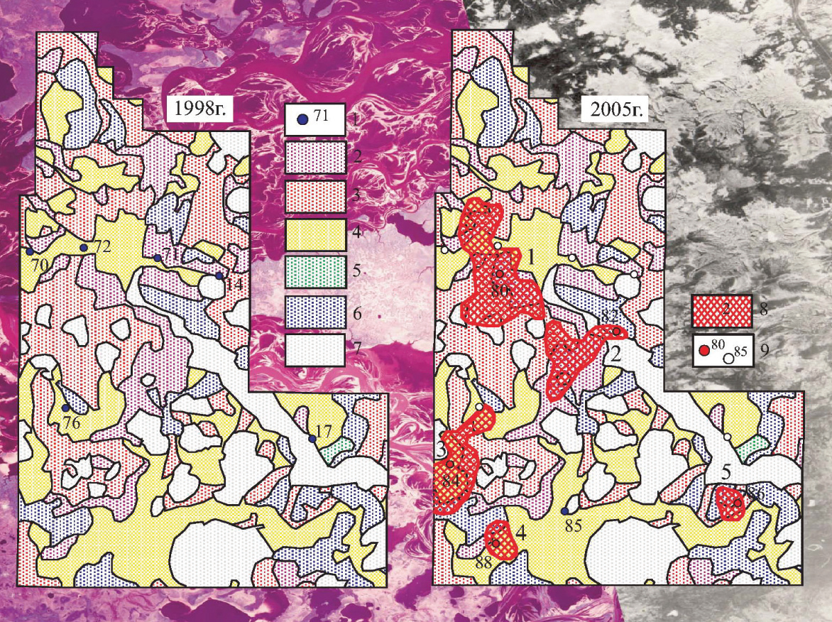
An example of confirmation by time of reliable oil forecast by space photography (Northern part of Severo-Yeguryakhsky prospect). Prior to space images decoding there were drilled 6 wells (Mark 1 in the Figure) in the area; all wells appeared to be non-productive.
In 1998 a map of oil presence forecast on space photography decoding was constructed, where the following zones were identified: supposedly highly productive zones (Mark 2); supposedly productive zones (3); supposedly low productive zones (4); supposedly «barren», i.e. unpromising for oil search. (6) A group of rejected areas for distant evaluation includes unreliably interpreted «cosmophotozones» (5) and natural obstacles (7) (lakes, channel flood plains).
In 7 years time there were drilled six «new» wells (with the numbers in the Figure on the right). These wells discovered 5 oilfields (Mark 8): Vostochno- Yanchinskoye (No.1), Yuzhno- Yanchinskoye (No.2), Zhilinskoye (No.3), Martovskoye (No.4) and Zapadno-Novoaganskoye. Only one of the fields (No.2, well 82) was inconsistent with the space photography oil presence forecast.
In 54 prospects and 8 license blocks, which were distantly mapped at the pre-drilling stage, after space images decoding, as much as 126 oilfields were identified. 90% of the ealuated discoveries (113 fields) were made in oil productive zones, defined by space photography data interpretation. Six discovery wells were drilled in the zones predicted to be barren. Seven oilfields (5%) according to space photography data interpretation are assessed as ambiguous.
Oil presence forecast by space photography decoding is a method of decoding of space images of the Earth used for detection of traces at its surface of hydrocarbon accumulations hidden at its depths. Such traces create space photography anomalies (SPA). The mapped outlines of such anomalies are interpreted as restrictions of the integral mapping of supposedly oil saturated pools. Space photography background for such «oil promising» anomalies is considered as mapping of areas unpromising for oil search.
Capability of distant identification of oil and gas accumulation traces is theoretically explainable from the standpoints of such discoveries in geology as «paragenesis event» and «hydrocarbon breathing».
Over hydrocarbon accumulations formed are geothermal-geochemical anomalies associated with ascending currents of gas-liquid fluids and heat flows, and also with physicalmechanical transformations; besides, electric, magnetic and other physical fields change. These anomalies, reflecting in spectral characteristics of their own and reflected electromagnetic radiation of natural objects are recorded as space photography anomalies.
Twenty years of experience of decoding of reconnaissance, regional and zonal space images in West Siberia has demonstrated a real possibility of distant forecast of oil- and gas-bearing zones on the basis of space photography anomalies.
This method allows to solve problems related not only to the identification of new oil-promising zones and areas, but also to the location of prospecting wells, which can be recommended for drilling.
The results of space photography decoding are taken into account in constructing annual maps and programs of geological and exploration works for the unallocated subsoil fund in RAC RSU of Yugra.