Activity directions >>> Scientific activity
Mathematical modeling of geological objects
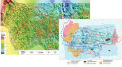
Surface modeling
The techniques of computerized construction of regional maps and structural frameworks were developed and they are constantly improving. The researchers of the Centre have developed and implemented their own mapping algorithms, that allow to construct highly detailed maps covering large territories using numerous geological, geophysical and other related information.
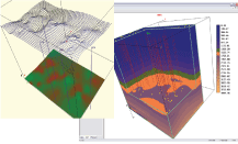
3D model
The technique of geological fields 3D modeling was successfully tested in real objects:
• 3D model of the sedimentary rocks compaction throughout the territory of Pomutskaya zone was developed;
• Paleostructure maps were constructed considering the compaction models;
• On the basis of VSP data there a 3D model of the depth field as a function of X,Y, T0 was constructed;
• Structural surfaces were constructed based on the information obtained by seismic crews and the depth field model.
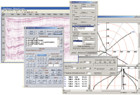
Morphological analysis
There was developed a tool for identification and analysis of structures with calculation of statistics parameters based on a set of attributes (amplitude, area, volume, rank, contours) and histogram construction.
On the basis of the surface specific points localization an algorithm of watershed and current lines search was developed, which were used for oil and gas presence forecast.
Tools
• Programmable calculator
• Inclinometry data processing
• Time cross-sections viewing
• Coordinates recalculation
Reserves estimation
There were implemented the algorithms for construction of fields of net oil- and gas-saturated, for calculation of fluid-saturated rock volumes, pore volume and the volume of the formation fluid, and issuance of volumes and reserves tables.
Templates and editors for various reserves categories were developed.
Probabilistic evaluation of surface models
At present a trend (techniques and algorithms) is being developed related to the evaluation of the accuracy of maps with various geologic parameters, probability of structures presence and the accuracy of reserves estimation.
Implementation of these techniques and their approval is planned at the oilfields of Khanty-Mansiysk Autonomous Okrug-Yugra.
Main activities of the department for mathematical simulation of geological objects.
• Surface modeling.
• 3D modeling.
• Morphological analysis.
• Reserves estimation.
• Probabilistic evaluation of surface models.