Activity directions >>> Scientific activity
Design of software and information processing systems
Software processing of complex information flows supports two directions:
– Creating and maintaining databases of specialized information, which are part of an integrated database of the Centre (accumulation of information);
– Construction of the space-information requests to an integrated database, the results of which take the form of constantly updated maps on various activities of the Center and allow solve analytical problems (generalization of information).
These directions define the different branches in a single information space of the Center, but have one trait in common in media solutions. Intrinsically, in each direction there is software of subdivision specialists. At the heart of every decision – the local database, which is either the result of, or an automation for obtaining results.
Database of wells survey
DB of wells survey contains the results of digital recording, results of digitizing the analog recording complex of wells survey at different scales. Downloaded data in DB of wells survey for 16 years collected information on more than 23 000 wells (more than 10 000 – exploratory). After screening and spatial coupling digital data come in DB of wells survey and are ready for operational processing of them.
Data of well survey are most important data for the formation and correction of the geological model, so the arrival and execution of queries to the database take place almost continuously.
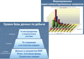
Database for monitoring of production activity
Production well ever drilled on the territory of the Okrug, the well production history and a monthly feature of work and the condition of each, as well as indicators of production activity of developed objects, licensed plots and fields are the universe of discourse of dataware.
Database is augmented of report documents from subsoil users, such as monthly exploitation report, a directory of wells and condition of well stock.
On a monthly basis about 500 report documents on well operation and well condition of more than 175 thousand wells from 83 oil production enterprises are sent to the database. Among other things, the base contains integrated estimate data on each well, enterprise, field, licensed subsoil plot, etc.
The quantity of data increases more than by 13 million records (documentation strings) every year, among them the primary data in 9 million records. The production database contains information over the last 19 years, includes more than 230 million records. The received data is tightly controlled for completeness and accuracy.
Findings are stringent controlled for completeness and consistency.
On the basis of collected information by a large set of standard reports is generated such as:
– The dynamics of basic performances of development;
– Distribution of low-yield foundation;
– Quarterly summary of the foundation's status.
In addition, many out-of-order queries to the base are performed, analytical tasks as «estimate of the effect from intensification», «predicted oil production», «Potential of oil extraction», «Potential of city-forming entities», and others.
Users of information are: The Government of the Yugra,Use of the Suboil Department of the KHMAO-Yugra, the Ecology Department of the KHMAO-Yugra, the Central Development Commission of Autonomous Okrug, subsoil users and subdivisions of the Centre.
Annually, more than one thousand documents presented in the form of tables, charts, etc are formed for problem solving.
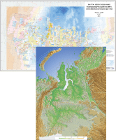
Thematic cartography
By means of geographic information systems (TNTmips, ArcGis) and additional internal design programs the access to the graphic layers and tabular information of integrated database of the Center occur. The query result is formed in the form of map. Each theme direction defines the content of such request, i.e. map's content. The process of map's layers updating, assembly and adjustment of its conventional sign are automated.
Annually (or several times a year) maps of the territory of Khanty-Mansiysk Autonomous Okrug with scale 1:1 000 000, 1:500 000, 1:200 000 updated by themes:
– substantiation of exploration work in the Okrug;
– licensing of the Yugra territory;
– nature management and production infrastructure;
– structural maps;
– seismic and drilling study.
The main activities of the department of development of software package, computer systems of information processing
• Database maintenance and creation to support monitoring of field development.
• Data analysis of production activity monitoring.
• Formation of standard documentation packages with exploitation coefficient of licensed plots of Yugra.
• Nonhost database maintenance and support with wells survey data.
• Preparation of thematic maps of the territory of the Khanty-Mansiysk Autonomous Okrug – Yugra.